Schoolnet Mozambique:Technology: Difference between revisions
No edit summary |
No edit summary |
||
| (3 intermediate revisions by 2 users not shown) | |||
| Line 1: | Line 1: | ||
{{Schoolnet_Mozambique nav bar}} | {{Schoolnet_Mozambique nav bar}} | ||
'''PHYSICAL LAYOUT''' | |||
The ideal physical layout for such a network would be having a central high point where an access point would be installed and all school would connect to that access point as remote stations. As such a central high point was not available at that time the schools themselves were used as repeating points. | |||
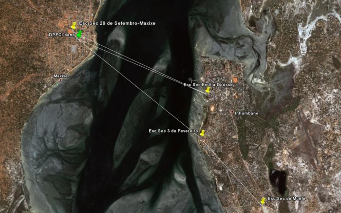
The way each school connects to the next one is the result of the best combination we could work out considering the line of sights that were available. For example the ES3Fev will only see points on the Maxixe side of the bay and not the ESEmiliaDausse which is also on the Inhambane side and at a much shorter distance that any point in Maxixe. | |||
The final physical layout of the network: The GoogleEarth view | |||
[[Image:Schoolnet Moz wifi network.jpg|thumb|left|700px|Satellite view of the Inhambane Schoolnet Network with links overlay]] | |||
Latest revision as of 16:36, 15 November 2007
PHYSICAL LAYOUT
The ideal physical layout for such a network would be having a central high point where an access point would be installed and all school would connect to that access point as remote stations. As such a central high point was not available at that time the schools themselves were used as repeating points. The way each school connects to the next one is the result of the best combination we could work out considering the line of sights that were available. For example the ES3Fev will only see points on the Maxixe side of the bay and not the ESEmiliaDausse which is also on the Inhambane side and at a much shorter distance that any point in Maxixe.
The final physical layout of the network: The GoogleEarth view
